Punched clouds
Punched Clouds: A Fascinating Atmospheric Phenomenon
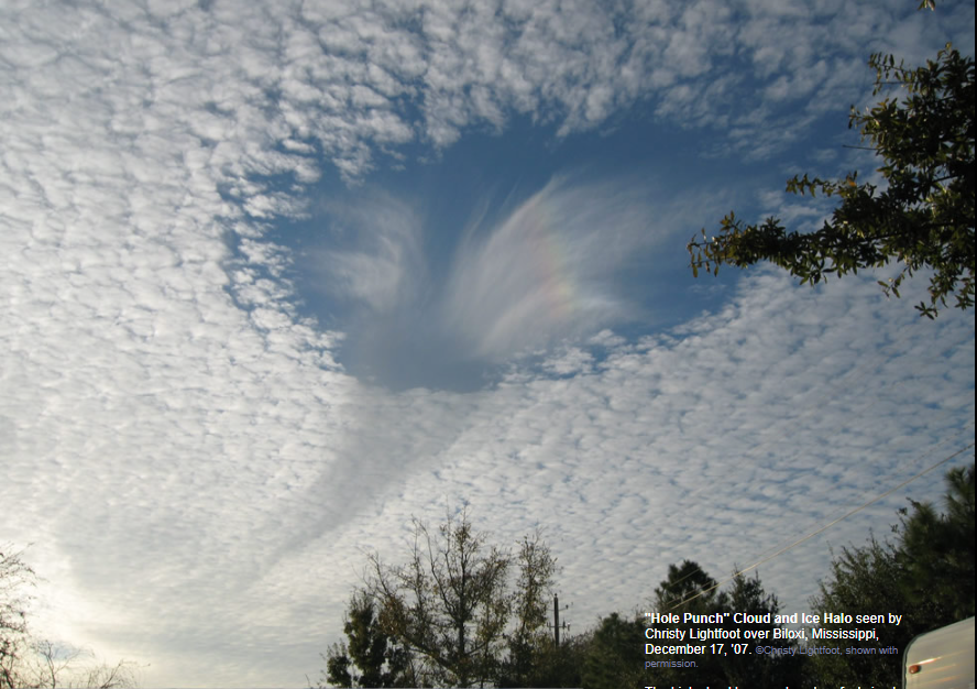
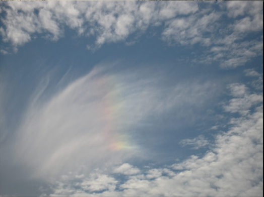
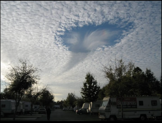
Clouds are not always the fluffy, uniform masses we imagine them to be. Occasionally, a peculiar phenomenon known as "punched clouds" occurs, captivating the attention of sky gazers. These clouds exhibit an almost perfect circular hole, with wispy ice crystals tumbling out from within. The presence of large ice crystals indicates that the fall streak is a fragment of a halo, adding to the allure of this optical spectacle.
The formation of these punched clouds stems from an instability within the cloud itself, although the exact details and triggers remain uncertain. To understand this phenomenon better, it is essential to delve into the behavior of water and ice in the atmosphere.
Contrary to popular belief, water does not always freeze at 0 degrees Celsius. In the absence of suitable nuclei for ice crystal growth, water droplets can remain in a supercooled state, meaning they remain liquid even at sub-zero temperatures. Clouds at intermediate temperatures often consist mainly of these tiny supercooled water droplets.
However, this metastable condition is thermodynamically unstable, as ice is the more stable state. When sufficient nuclei are introduced or when the cloud is disturbed, ice crystals begin to grow rapidly. This happens because the equilibrium vapor pressure of water over supercooled droplets is greater than that over ice at the same temperature. Furthermore, the process of ice crystallization releases heat, facilitating its rapid growth. As a result, the cloud transitions from one composed of supercooled water droplets to one predominantly consisting of ice crystals.
Interestingly, this mechanism is not unique to punched clouds; it plays a vital role in the formation of rain as well. In typical clouds, water droplets cannot collide and coalesce enough to form large raindrops. However, ice crystals have the ability to grow and cluster into intricate snowflakes. Consequently, the cloud either snows or, if temperatures are higher, the snowflakes melt into raindrops.
What sets punched clouds apart is the sudden transformation of a relatively small region within the cloud. This localized disturbance leads to the conversion of supercooled droplets into large ice crystals, creating a distinctive hole. In some instances, a cloud layer may even be marked by multiple holes, further enhancing the visual spectacle.
Several hypotheses exist to explain the necessary localized disturbances that trigger punched clouds. One possibility is that falling ice crystals from higher cloud fragments initiate the process. Alternatively, disturbances caused by high-altitude aircraft or natural turbulence and air currents at higher and medium levels can disrupt the delicate metastable state.
As we marvel at these punched clouds and their mesmerizing beauty, it serves as a reminder of the intricacies and wonders of our atmosphere. By delving into the science behind this phenomenon, we gain a deeper appreciation for the complex interplay between temperature, water, ice, and the delicate balance that exists within our skies.

"Hole Punch" Cloud and Ice Halo seen by Christy Lightfoot over Biloxi, Mississippi, December 17, '07. ©Christy Lightfoot, shown with permission.
The high cloud has an almost perfect circular hole. From within it tumbles a wispy fall streak of ice crystals. We know that at least some of the streak is composed of large ice crystals because they have formed a fragment of a halo.
The hole arises from an instability in the cloud but the details and what triggers it are not certain.
Water does not always freeze at 0 degrees Celsius. If no nuclei are present on which ice crystals can grow (heterogeneous nucleation) the water can remain at sub-zero temperatures - it is supercooled. At sufficiently low temperatures spontaneous nucleation occurs but clouds at intermediate temperatures can be composed largely of tiny supercooled water droplets.
Thermodynamically this is a metastable condition because ice is the more stable state. Introduce enough nuclei or otherwise disturb the cloud and ice crystals grow very rapidly.
This happens because the equilibrium vapour pressure of water over supercooled droplets is greater than that over ice at the same temperature and because ice crystallisation releases heat. Once ice crystallisation starts it continues rapidly with the necessary water vapour supplied by evaporation of the surrounding water drops. Very soon we have a cloud largely of ice crystals rather than one of supercooled water drops.
This is not special. It is one of the major mechanisms by which rain forms. The water drops in clouds are not usually able to collide and coalesce sufficiently to form large raindrops. Ice crystals can, however, easily grow and cluster into snowflakes. The cloud then snows, or if the temperatures are high enough, the flakes melt into raindrops.
What is unusual is that a relatively small (several hundred metres) region of a cloud should suddenly transform from supercooled droplets into large ice crystals leaving a hole. Sometimes a cloud layer is riven by several holes.
Several unproven hypotheses exist to explain the necessary localised disturbance. Falling ice crystals from higher cloud fragments might initiate the process. Disturbances by high level aircraft have been suggested. Natural high and medium level turbulence and air currents can disturb the delicate metastable state.


Note: this article has been automatically converted from the old site and may not appear as intended. You can find the original article here.
Reference Atmospheric Optics
If you use any of the definitions, information, or data presented on Atmospheric Optics, please copy the link or reference below to properly credit us as the reference source. Thank you!
-
<a href="https://atoptics.co.uk/blog/punched-clouds/">Punched clouds</a>
-
"Punched clouds". Atmospheric Optics. Accessed on November 26, 2024. https://atoptics.co.uk/blog/punched-clouds/.
-
"Punched clouds". Atmospheric Optics, https://atoptics.co.uk/blog/punched-clouds/. Accessed 26 November, 2024
-
Punched clouds. Atmospheric Optics. Retrieved from https://atoptics.co.uk/blog/punched-clouds/.