OPOD - Linear 'Hole Punch'
OPOD - Linear 'Hole Punch': A Magnificent Atmospheric Phenomenon
Have you ever looked up at the sky and witnessed a peculiar sight? One such captivating phenomenon is the linear 'hole punch'. This atmospheric optical display is a mesmerizing spectacle that spans the heavens, leaving observers in awe of its beauty and mystery. Let's delve deeper into this intriguing occurrence and explore the science behind it.
A Spectacular Skyward Sight
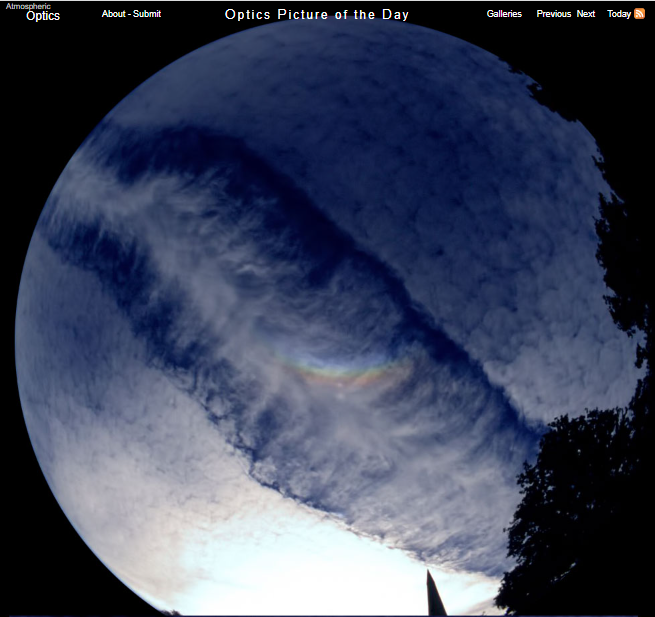
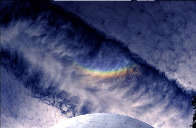
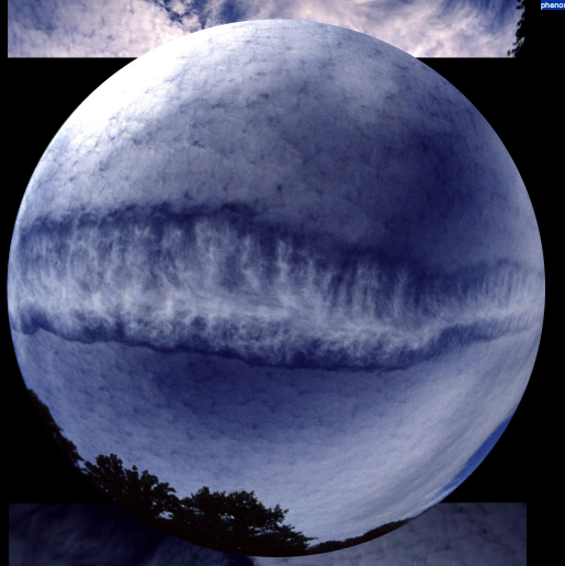
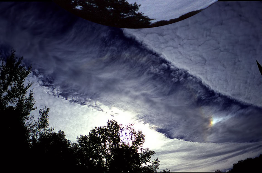
The linear 'hole punch' is a striking atmospheric phenomenon that can be witnessed in certain weather conditions. Captured by Wolfgang Hinz in Chemnitz, Saxony, Germany on October 22nd, 1997, this magnificent event left an indelible mark on those fortunate enough to witness it. The expansive 'hole punch' adorned the sky, creating a spectacle that was both awe-inspiring and perplexing.
Ice Crystals and Optical Wonders
At the heart of this mesmerizing display lie large ice crystals. These crystals are formed when supercooled droplets within the cloud layer suddenly convert into larger ice crystals. The instability within the cloud causes these ice crystals to fall out of the cloud, resulting in a visible hole in the cloud formation. The ice crystals, being less opaque than the surrounding cloud, allow light to pass through, creating a striking visual effect.
Triggers and Origins
Several factors can trigger the formation of a hole punch. One possible trigger is disturbance by an aircraft passing through the cloud layer. The disturbance caused by the aircraft can disrupt the supercooled droplets, leading to their rapid conversion into ice crystals. Another potential trigger is the presence of ice crystals acting as nuclei or seed crystals, tumbling downwards from higher clouds or contrails. These ice crystals can initiate the transformation process within the cloud layer, giving rise to the formation of a hole punch.
Supercooled Droplets and Metastability
Clouds with supercooled droplets form when water does not freeze at the standard freezing point of zero degrees Celsius. In the absence of nuclei or other factors that promote ice crystal growth, the cloud water droplets remain in their liquid state and cool to sub-zero temperatures. This condition is known as metastability, where the ice phase is the more stable state. However, the introduction of sufficient nuclei or disturbances within the cloud can rapidly promote the growth of ice crystals at the expense of the supercooled droplets.
Unusual Transformation Patterns
While the transformation of supercooled droplets to ice crystals is a normal occurrence, what makes hole punches and similar phenomena peculiar is that this transformation takes place only in small patches. Unlike rain formation, where ice crystals coalesce into larger snowflakes that subsequently melt as they descend, hole punches exhibit localized conversion from supercooled droplets to ice crystals. The resulting pattern is a linear configuration, possibly induced by the passage of a higher aircraft or other factors that are yet to be fully understood.
The Fascinating Mystery Continues
Despite our understanding of the basic mechanisms behind hole punches, there is still much to uncover about these enigmatic atmospheric phenomena. Scientists and sky enthusiasts alike continue to study and document these occurrences, aiming to unravel the complexities and intricacies that give rise to such captivating displays. The linear 'hole punch' serves as a reminder of the ever-present wonders that await us in the vast expanse above.
In conclusion, the linear 'hole punch' is a remarkable atmospheric optics phenomenon that leaves spectators in awe of its beauty and intrigue. The interplay between supercooled droplets and ice crystals within the cloud layer gives rise to this mesmerizing display. As we continue to unravel the secrets of the sky, let us cherish and marvel at the wonders that nature graciously presents to us.

Linear 'Hole Punch'
Imaged by Wolfgang Hinz (Atmospheric Phenomena) at Chemnitz, Saxony, Germany 22nd October '97. ©Wolfgang Hinz, shown with permission

This magnificent 'hole punch' spanned the sky.
Large ice crystals falling from it formed a circumzenithal arc and (lowest image) a sundog.
Hole punches are thought to result from an instability causing supercooled droplets already in the cloud layer to suddenly convert to large ice crystals. The ice crystals fall out of the cloud and are in any case less opaque � we therefore see a hole.
A trigger for the instability might be disturbance by an aircraft. Another trigger could be ice crystals that act as nuclei, seed crystals, tumbling downwards from higher cloud or a contrail.
Clouds with supercooled droplets arise because water does not always freeze at zero degrees Celsius. If no nuclei are present on which ice crystals can grow, the cloud water droplets remain and cool to sub-zero temperatures. The condition is metastable in that ice is the more stable state. Introduce enough nuclei or otherwise disturb the cloud and ice crystals grow very rapidly at the expense of the droplets.
This is a normal. Rain can form that way from an initial formation of ice crystals coagulating into larger snowflakes which subsequently melt as they descend. What is strange is that in hole punches and their like, the supercooled droplet to ice transformation takes place only in small patches.
This linear version could be induced by passage a higher aircraft or there could be another interpretation to the whole phenomenon.


Note: this article has been automatically converted from the old site and may not appear as intended. You can find the original article here.
Reference Atmospheric Optics
If you use any of the definitions, information, or data presented on Atmospheric Optics, please copy the link or reference below to properly credit us as the reference source. Thank you!
-
<a href="https://atoptics.co.uk/blog/opod-linear-hole-punch/">OPOD - Linear 'Hole Punch'</a>
-
"OPOD - Linear 'Hole Punch'". Atmospheric Optics. Accessed on November 26, 2024. https://atoptics.co.uk/blog/opod-linear-hole-punch/.
-
"OPOD - Linear 'Hole Punch'". Atmospheric Optics, https://atoptics.co.uk/blog/opod-linear-hole-punch/. Accessed 26 November, 2024
-
OPOD - Linear 'Hole Punch'. Atmospheric Optics. Retrieved from https://atoptics.co.uk/blog/opod-linear-hole-punch/.