Iridescent & Nacreous Clouds - OPOD
Iridescent & Nacreous Clouds: A Mesmerizing Display of Atmospheric Optics
Clouds have always captivated our imagination with their ever-changing forms and colors. Among the myriad of cloud types, iridescent and nacreous clouds stand out for their breathtaking beauty. These ethereal phenomena, although visually similar, occur at different altitudes and under specific atmospheric conditions. In this article, we will delve into the mesmerizing world of iridescent and nacreous clouds, exploring their characteristics, formation, and where they can be observed.
Iridescent Clouds: Nature's Prismatic Masterpieces
Iridescent clouds, also known as "fire rainbows" or "rainbow clouds," are a dazzling display of colors that seem to dance across the sky. These filmy clouds often appear in the vicinity of towering cumulus clouds and are caused by a phenomenon known as pileus formation. Pileus clouds form when moist air layers are forced upward by the rapidly growing cumulus clouds beneath them. The moist air cools and condenses, creating tiny droplets that diffract sunlight, resulting in the iridescent hues we observe.
Key points about iridescent clouds:
- They are commonly mistaken for nacreous clouds due to their captivating colors.
- Iridescent clouds occur at lower altitudes compared to nacreous clouds.
- Brazil's latitudes are not conducive to the formation of nacreous clouds.
Nacreous Clouds: Pearlescent Spectacles in the Stratosphere
In stark contrast to iridescent clouds, nacreous clouds grace the higher reaches of our atmosphere, specifically in the stratosphere. These mesmerizing cloud formations exhibit intense brightness and wavelike patterns that resemble the iridescence found in pearls, hence their name "nacreous." They are a rare sight, occurring primarily during high latitude winters when stratospheric temperatures drop below an astonishing -85 degrees Celsius.
Key points about nacreous clouds:
- Nacreous clouds are found at higher altitudes, between 9 to 16 miles in the stratosphere.
- They require below-average stratospheric temperatures for their formation.
- These captivating clouds are restricted to high latitude winters.
A Visual Journey: Images of Iridescent and Nacreous Clouds
To truly appreciate the allure of these atmospheric optics phenomena, let us embark on a visual journey through some stunning images captured by photographers who were fortunate enough to witness these awe-inspiring displays.
-
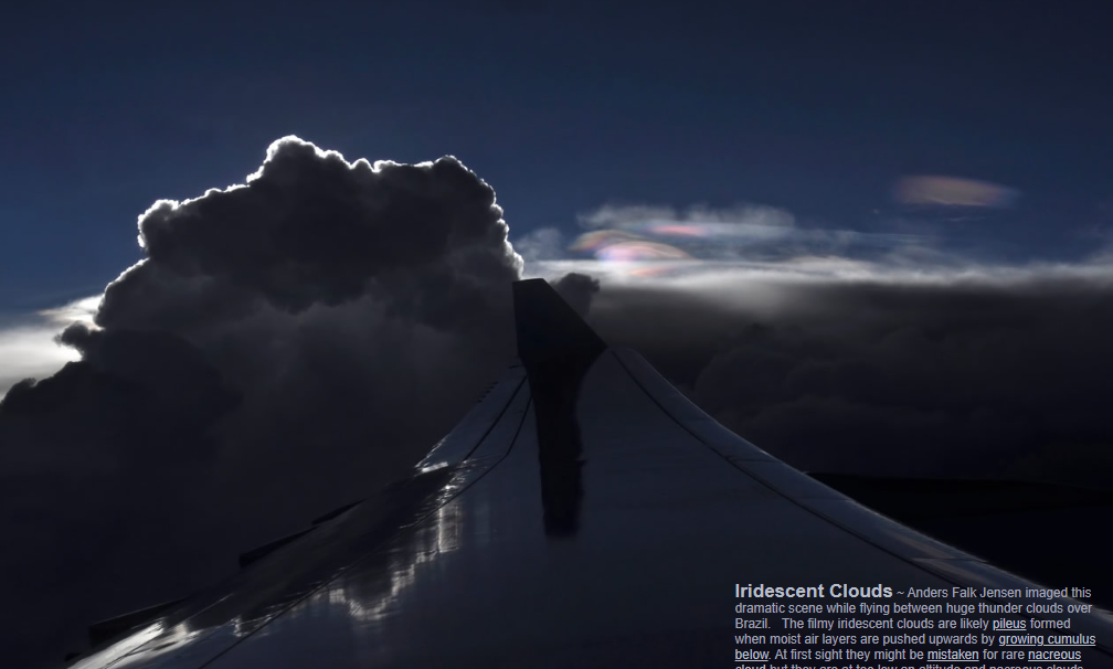
Image by Anders Falk Jensen: Flying between colossal thunder clouds over Brazil, Jensen captured a dramatic scene showcasing the filmy iridescent clouds. These clouds, resembling nacreous clouds at first glance, are actually pileus clouds formed due to the upward push of moist air layers by growing cumulus clouds below. This image serves as a reminder that even at lower altitudes, nature can still create prismatic wonders.
-
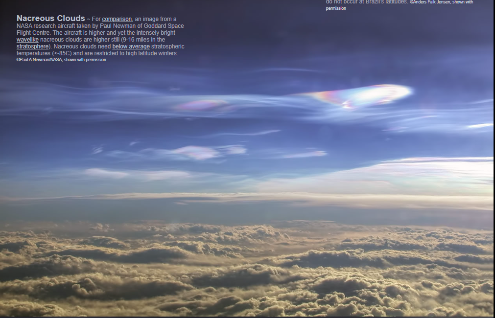
Image by Paul Newman: Taken from a NASA research aircraft, this photograph by Paul Newman showcases the intense brightness and wavelike patterns of nacreous clouds in the stratosphere. The aircraft's higher altitude allows for a unique perspective on these pearlescent spectacles. The ethereal beauty of nacreous clouds is truly a testament to the intricate dance between temperature and atmospheric conditions.
-
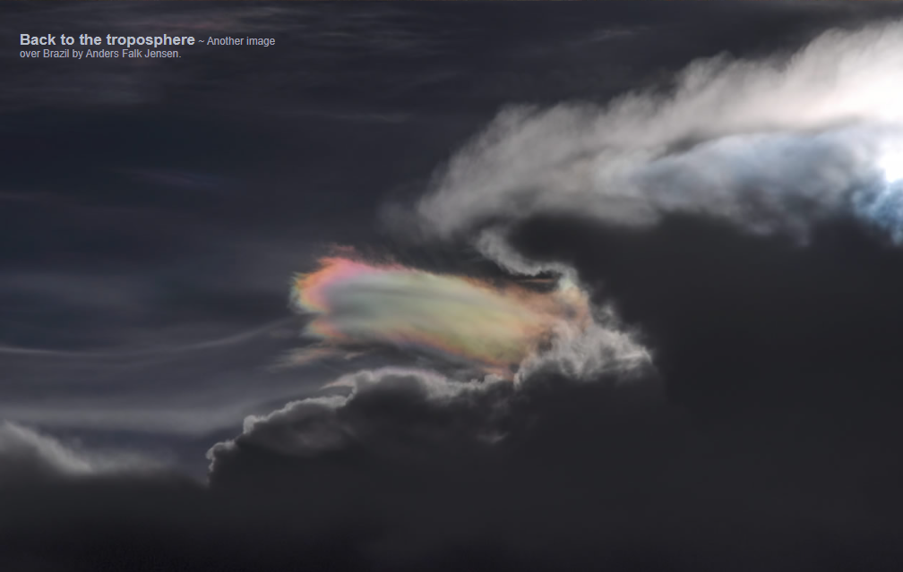
Another image by Anders Falk Jensen: Returning to the troposphere, Jensen's photograph over Brazil captures yet another mesmerizing display of iridescent clouds. The interplay of light and moisture creates a captivating tapestry of colors that seems almost otherworldly.
Conclusion: A Glimpse into Nature's Artistry
Iridescent and nacreous clouds offer us a glimpse into the remarkable artistry of our planet's atmosphere. Whether it's the iridescent hues dancing among towering cumulus clouds or the pearlescent waves painting the high latitude stratosphere, these atmospheric phenomena remind us of the sheer beauty and complexity of our natural world. So, the next time you cast your eyes skyward, keep an eye out for these enchanting displays, for they are fleeting masterpieces that leave us in awe of the wonders that surround us.

Iridescent Clouds ~ Anders Falk Jensen imaged this dramatic scene while flying between huge thunder clouds over Brazil. The filmy iridescent clouds are likely pileus formed when moist air layers are pushed upwards by growing cumulus below. At first sight they might be mistaken for rare nacreous cloud but they are at too low an altitude and nacreous clouds do not occur at Brazil’s latitudes. ©Anders Falk Jensen, shown with permission
Back to the troposphere ~ Another image

Nacreous Clouds ~ For comparison, an image from a NASA research aircraft taken by Paul Newman of Goddard Space Flight Centre. The aircraft is higher and yet the intensely bright wavelike nacreous clouds are higher still (9-16 miles in the stratosphere). Nacreous clouds need below average stratospheric temperatures (<-85C) and are restricted to high latitude winters. ©Paul A Newman/NASA, shown with permission

Back to the troposphere ~ Another image over Brazil by Anders Falk Jensen.
Note: this article has been automatically converted from the old site and may not appear as intended. You can find the original article here.
Reference Atmospheric Optics
If you use any of the definitions, information, or data presented on Atmospheric Optics, please copy the link or reference below to properly credit us as the reference source. Thank you!
-
<a href="https://atoptics.co.uk/blog/iridescent-nacreous-clouds-opod/">Iridescent & Nacreous Clouds - OPOD</a>
-
"Iridescent & Nacreous Clouds - OPOD". Atmospheric Optics. Accessed on November 26, 2024. https://atoptics.co.uk/blog/iridescent-nacreous-clouds-opod/.
-
"Iridescent & Nacreous Clouds - OPOD". Atmospheric Optics, https://atoptics.co.uk/blog/iridescent-nacreous-clouds-opod/. Accessed 26 November, 2024
-
Iridescent & Nacreous Clouds - OPOD. Atmospheric Optics. Retrieved from https://atoptics.co.uk/blog/iridescent-nacreous-clouds-opod/.