Nacreous Clouds _ Atmospheric Optics
Nacreous Clouds: A Spectacular Display of Atmospheric Optics
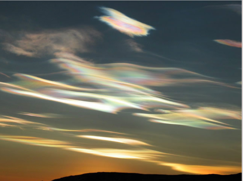
Nacreous clouds, also known as mother-of-pearl clouds, are a breathtaking phenomenon that leaves a lasting impression on anyone fortunate enough to witness them. These rare cloud formations exhibit vibrant and ever-changing iridescent colors, casting an ethereal glow across the sky. Unlike their low altitude counterparts, nacreous clouds appear in the stratosphere, soaring at heights of 15 to 25 kilometers (9 to 16 miles) above the Earth's surface. Their mesmerizing display is most commonly observed within two hours after sunset or before dawn, when they remain illuminated by the sun's rays.
The Striking Appearance of Nacreous Clouds
Nacreous clouds present themselves as delicate, filmy sheets that gracefully curl and unfurl, expanding and contracting against the semi-dark sky. Their undulating sheet-like forms provide a visual testament to the winds and waves of the stratosphere. Despite their delicate appearance, nacreous clouds command attention as they majestically hold their position amidst the vast expanse of the sky. This characteristic makes them a remarkable indicator of their considerable altitude.
The Optimal Conditions for Nacreous Cloud Formation
To witness nacreous clouds, one must venture into the frigid regions of the lower stratosphere, where temperatures plummet to extreme lows. These icy conditions, found between 15 and 25 kilometers above the Earth's surface, create the perfect environment for the formation of these extraordinary clouds. It is within these heights that nacreous clouds continue to reflect sunlight even after sunset or before dawn, resulting in their striking brightness.
Geographic Distribution and Seasonal Occurrence
Nacreous clouds predominantly make their appearance during winter at high latitudes, gracing regions such as Scandinavia, Iceland, Alaska, and Northern Canada with their captivating presence. However, on occasion, these clouds can surprise observers as they manifest further south, reaching as far as England. Downwind of mountain ranges, nacreous clouds can also be observed with less rarity. Furthermore, their occurrence is often linked to severe tropospheric winds and storms, adding to the spectacle of their formation.
Nacreous Clouds vs. Ordinary Iridescent Clouds
While iridescent clouds in the troposphere are relatively common and can be observed worldwide, nacreous clouds surpass them in both luminosity and color intensity. The vivid hues exhibited by nacreous clouds distinguish them from their lower-level counterparts. The stark contrast between these cloud types is evident, highlighting the exceptional nature of nacreous clouds.
Conclusion
Nacreous clouds represent a remarkable display of atmospheric optics, captivating observers with their radiant iridescence and graceful movements. The rarity of these clouds only enhances their allure, leaving a lasting impression on those fortunate enough to witness their beauty. By understanding the optimal conditions for their formation and their geographic distribution, we can appreciate the privilege of encountering these extraordinary natural phenomena. Whether observed in the frigid regions of the Arctic or unexpectedly gracing the skies of more temperate locations, nacreous clouds serve as a reminder of the awe-inspiring wonders that our atmosphere holds.
Nacreous Clouds over Antarctica Imaged by Cherie Ude at McMurdo Base in 2004.
Nacreous clouds (Type II PSCs) glow brightly with vivid iridescent colours.
They are wave clouds and their undulating sheet-like forms reveal the winds and waves of the stratosphere.
©Cherie Ude, shown with permission.
Nacreous clouds, sometimes called mother-of-pearl clouds, are rare but once seen are never forgotten. They are mostly visible within two hours after sunset or before dawn when they blaze unbelievably bright with vivid and slowly shifting iridescent colours. They are filmy sheets slowly curling and uncurling, stretching and contracting in the semi-dark sky. Compared with dark scudding low altitude clouds that might be present, nacreous clouds stand majestically in almost the same place - an indicator of their great height.
They need the very frigid regions of the lower stratosphere some 15 - 25 km (9 -16 mile) high and well above tropospheric clouds. They are so bright after sunset and before dawn because at those heights they are still sunlit.
They are seen mostly during winter at high latitudes like Scandinavia, Iceland, Alaska and Northern Canada. Sometimes, however, they occur as far south as England. They can be less rare downwind of mountain ranges. Elsewhere their appearance is often associated with severe tropospheric winds and storms.
Nacreous or ordinary iridescent clouds? Lower level iridescent clouds in the troposphere are far more common and are seen all over the world. Nacreous clouds far outshine them and have much more vivid colours. The differences are highlighted on this page.
Note: this article has been automatically converted from the old site and may not appear as intended. You can find the original article here.
Reference Atmospheric Optics
If you use any of the definitions, information, or data presented on Atmospheric Optics, please copy the link or reference below to properly credit us as the reference source. Thank you!
-
<a href="https://atoptics.co.uk/blog/nacreous-clouds-atmospheric-optics/">Nacreous Clouds _ Atmospheric Optics</a>
-
"Nacreous Clouds _ Atmospheric Optics". Atmospheric Optics. Accessed on April 25, 2024. https://atoptics.co.uk/blog/nacreous-clouds-atmospheric-optics/.
-
"Nacreous Clouds _ Atmospheric Optics". Atmospheric Optics, https://atoptics.co.uk/blog/nacreous-clouds-atmospheric-optics/. Accessed 25 April, 2024
-
Nacreous Clouds _ Atmospheric Optics. Atmospheric Optics. Retrieved from https://atoptics.co.uk/blog/nacreous-clouds-atmospheric-optics/.